Deliver stronger road asset management projects with flexible support​

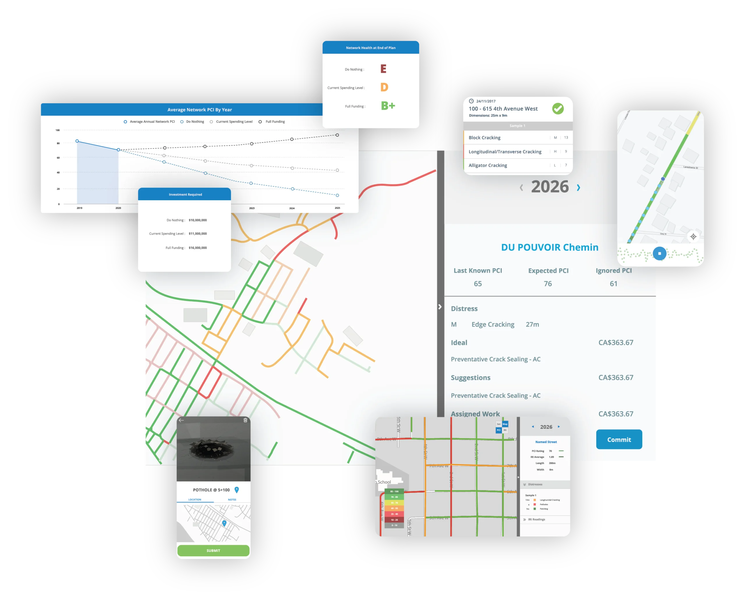
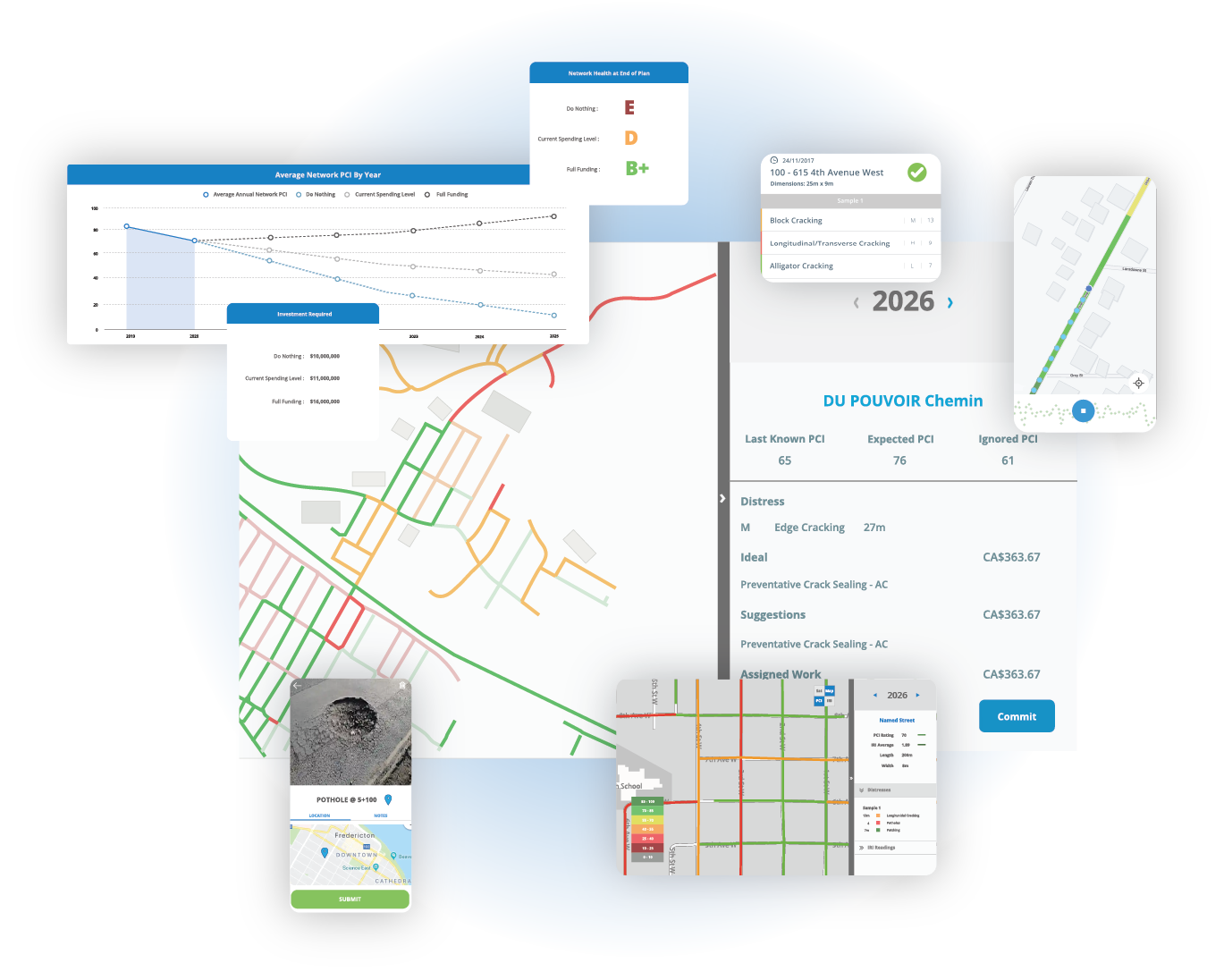
TotalPave helps asset management consultants deliver road needs studies, pavement management plans, analytics projections, and paving and maintenance recommendations. Use our IRI, PCI, SurfaceView PCI, and WorkPlan Analytics tools in the way that best fits the project.

IRI and PCI
Field data collection
SurfaceView
Imagery-based PCI
WorkPlan
Scenario analytics
Exports
GIS and reports
FLEXIBLE DELIVERY

Multiple delivery models that fit your project needs

Use TotalPave as your software platform, field partner, analysis team, or a combination of all three. The scope can be adapted to your client, schedule, and internal capacity.

Consultant-led

License TotalPave software so your staff can collect condition data, review the portal, complete analysis, and prepare the final client report.

TotalPave-led​

TotalPave can complete field data collection, or SurfaceView PCI processing and provide organized results for your larger study.

Hybrid

Split the work by geography, collection method, schedule, or expertise. Your team and TotalPave can contribute to one coordinated project dataset.

Back-end Support

Bring us existing or newly collected data for condition projections, budget scenarios, treatment analysis, and paving or maintenance recommendations.

CONSULTANT TOOLKIT

One platform for collection, analytics, and client-ready outputs

Use the full TotalPave toolkit or only the pieces your project needs. Consultants can handle collection directly, use TotalPave to fill gaps, or rely on TotalPave for data processing and analytics support.

TotalPave IRI​

Collect ride quality and roughness data with smartphone-based field workflows.

TotalPave PCI

Complete guided pavement condition surveys with distress type, severity, and extent.

SurfaceView PCI

Turn roadway imagery into PCI results and distress-level outputs when walking surveys are not practical.

WorkPlan Analytics​

Compare treatments, budgets, and planning scenarios to build practical recommendations.

HOW IT WORKS

A flexible workflow for road needs studies and pavement plans

TotalPave can support a single part of the project or the full path from road data collection to maintenance and paving recommendations.

Step 1

Set Up

Start with existing GIS road centerlines or automatically generate interval-based road segments for your client’s network.

Step 2

Collect

Use TotalPave mobile tools to collect IRI and PCI data with vehicles and phones you already have.

Step 3

Analyze

Review condition maps, segment scores, inspection records, and planning analytics in the web portal.

Step 4

Plan

Build a clear maintenance and paving plan that supports budgets, priorities, and council-ready recommendations.

CLIENT-READY OUTPUTS

Turn condition data into evidence your clients can use

Consulting reports need more than raw scores. TotalPave helps organize road condition results into mapped, exportable, and defensible outputs that support recommendations, budgets, and implementation plans.
Condition maps
Visualize IRI, PCI, treatment need, priority, and other planning layers.
Paving and maintenance recommendations
Build outputs around treatments, timing, and available budgets.
Budget scenarios and projections
Compare funding levels and show the long-term impact of different investment levels.
GIS and spreadsheet exports

Move results into client systems, internal models, and report appendices.

Maps
Condition and treatment views
Tables
Segment-level records
Exports
GIS and spreadsheets
WHERE IT FITS

Support that fits your clients' needs

TotalPave is built to fit inside practical consulting workflows, from one-time condition assessments to recurring pavement management programs.

Road needs studies

Collect current IRI and PCI data, identify condition patterns, and support near-term paving priorities.

Asset management plans

Feed condition scores, replacement timing, and maintenance strategies into larger municipal asset management projects.

Pavement management plans

Use mapped data and analytics to create defensible treatment recommendations and budget scenarios.

Annual paving programs

Help clients move from complaints and staff judgment to project lists supported by current condition data.

Grant and funding support

Use condition data and scenario outputs to support funding requests, council discussions, and capital planning.

Baseline network assessments

Create an initial condition inventory for municipalities, campuses, airports, private roads, and other managed networks.

FAQ

Consulting FAQs

Answers to the common setup, collection, export, and planning questions consulting firms usually ask.

Do we need special equipment?

No. TotalPave is designed around smartphone-based data collection using standard vehicles and practical field workflows.

Yes. Consultant staff can collect IRI and PCI after setup and training. SurfaceView imagery can also be collected by your team when collection requirements are followed.

GIS road centerlines are helpful, but they are not always required. TotalPave can work with existing GIS data or create interval-based road segments when needed.

TotalPave combines condition data, segment-level scores, and analytics tools to help identify which roads should be considered for maintenance, rehabilitation, paving, or future monitoring.

Yes. Data can be exported for GIS, spreadsheets, reports, asset management plans, and other municipal planning workflows.

Yes. Data and outputs can be exported for your own analysis, GIS work, reporting templates, presentations, and final client deliverables.

PROJECT SUPPORT

Need Support For Your Next Project?

Share the project scope, network size, timeline, and required outputs. We’ll recommend the optimal delivery approach and outline the next steps to ensure your project is delivered on time and on budget.

Choose the right delivery model
Software license, TotalPave field support, analytics support, or a hybrid workflow.
Plan around the client deadline
Set up the collection, review, and reporting process before the project schedule gets tight.
Export the outputs your team needs
Use maps, tables, GIS files, spreadsheets, and planning outputs in your own deliverables.

Get totalPave on your side for your next project

Share a few details and we will follow up with recommended next steps.