Active Transportation Asset Management Software
TotalPave provides active transportation asset management software for collecting condition data on bike lanes, trails, sidewalks, and multi-use paths using practical mobile workflows.
Bike-mounted TotalPave IRI
Mount a smartphone securely to the bicycle handlebars and ride the target paths to collect roughness data. Results are organized by mapped segment so teams can identify uncomfortable sections, compare corridors, and monitor changes in ride quality over time.
TotalPave PCI
Complete the same guided visual pavement condition assessment used on road networks. Inspect representative samples and record distress type, severity, and extent to produce section-level PCI results for paths and trails.
Bike-mounted SurfaceView PCI
Mount a suitable camera to your handlebars and collect clear, georeferenced imagery as you ride. TotalPave processes the footage into PCI scores and distress-level outputs when walking surveys are not practical.
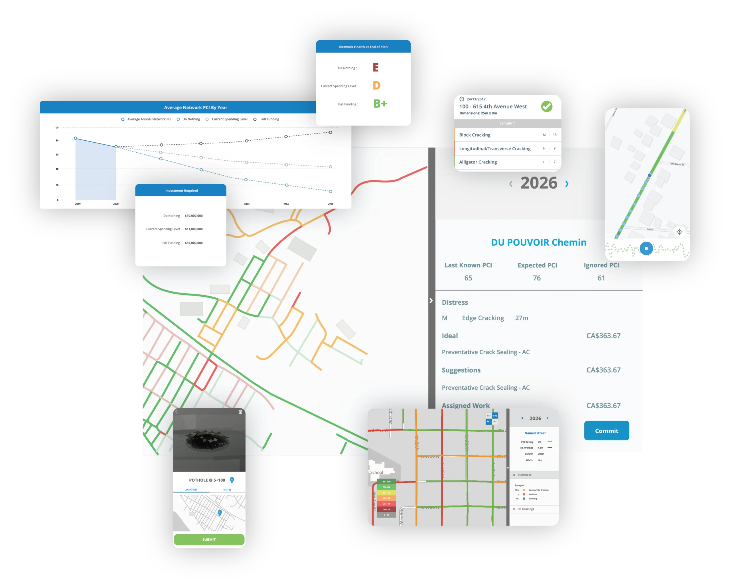
WorkPlan Analytics
Combine IRI, PCI, budgets, treatment options, and planning rules to compare scenarios and develop maintenance and rehabilitation strategies for the active transportation network.
Everything you need for bike path and trail condition planning
Collect active transportation condition data, review mapped results, compare planning scenarios, and export outputs for asset management, grants, and capital planning.
Complete guided pavement condition surveys on paths and paved trails using the TotalPave PCI app, with distress type, severity, and extent.
Condition Mapping
View active transportation segments by condition, treatment need, priority, or route type so network issues are easier to understand.
Use IRI and PCI results to support renewal timing, treatment selection, and long-term maintenance planning.
Budget Scenarios
Compare funding levels and understand how investment choices affect future active transportation network condition.
Reports and Exports
Export data for GIS, spreadsheets, grant reporting, asset management plans, and council or board materials.
From path data to an Actionalable renewal plan
Set Up
Start with existing route GIS files or create interval-based segments for trails, bike paths, and multi-use networks.
Collect
Collect IRI with a handlebar-mounted phone, complete PCI surveys in the field, or collect handlebar-mounted imagery for SurfaceView PCI.
Review
Review mapped results, segment scores, inspection records, imagery outputs, and planning analytics in the web portal.
Plan
Build a clear maintenance and renewal plan for paving, preservation, repair, and future monitoring.
Active transportation network FAQs
Do we need special equipment?
No. IRI can be collected with a smartphone mounted to bicycle handlebars. PCI uses the TotalPave PCI app to facilitate a visual assessment. SurfaceView PCI can use handlebar-mounted camera imagery when imagery-based assessment is preferred.
Can our own staff collect the data?
Yes. Staff can collect IRI, PCI, and imagery data using TotalPave workflows. TotalPave can also help with setup, review, SurfaceView PCI processing, and analytics.
Do we need GIS files to get started?
Route GIS files are helpful, but they are not always required. TotalPave can work with existing GIS data or create interval-based segments when needed.
How does TotalPave support renewal planning?
TotalPave combines condition data, segment-level scores, maps, and analytics to help identify which paths should be monitored, repaired, preserved, resurfaced, or reconstructed.
Can the results be exported?
Yes. Data can be exported for GIS, spreadsheets, grant reports, asset management plans, and internal planning workflows.
Can TotalPave help us create a network plan?
Yes. TotalPave analytics can be used to generate recommended maintenance and renewal plans based on active transportation condition data and available budget.
Ready to build a defensible active transportation plan?
Tell us about your current active transportation asset management software and planning process. We will help you understand the simplest way to collect IRI and PCI data, review results, and turn them into renewal recommendations.
What happens next?
After you submit the form, we will review your active transportation network requirements and follow up with the best setup and workflow options.