Road Asset Management Software for Defensible Paving Plans
TotalPave is road asset management software that helps municipalities collect IRI and PCI data, map road conditions, compare needs across road sections, and build practical maintenance and paving plans.
The planning process gets harder when decisions are based on partial information and out-of-date road asset management software.
-
Limited budgets
-
Small teams
-
Incomplete condition data
-
Pressure to justify decisions
What better data makes possible
Consistent condition data and clear analytics give staff a stronger foundation for planning and reporting.
Clearer paving priorities
Consistent network-wide scores
Budget-ready recommendations
Defensible asset management plans
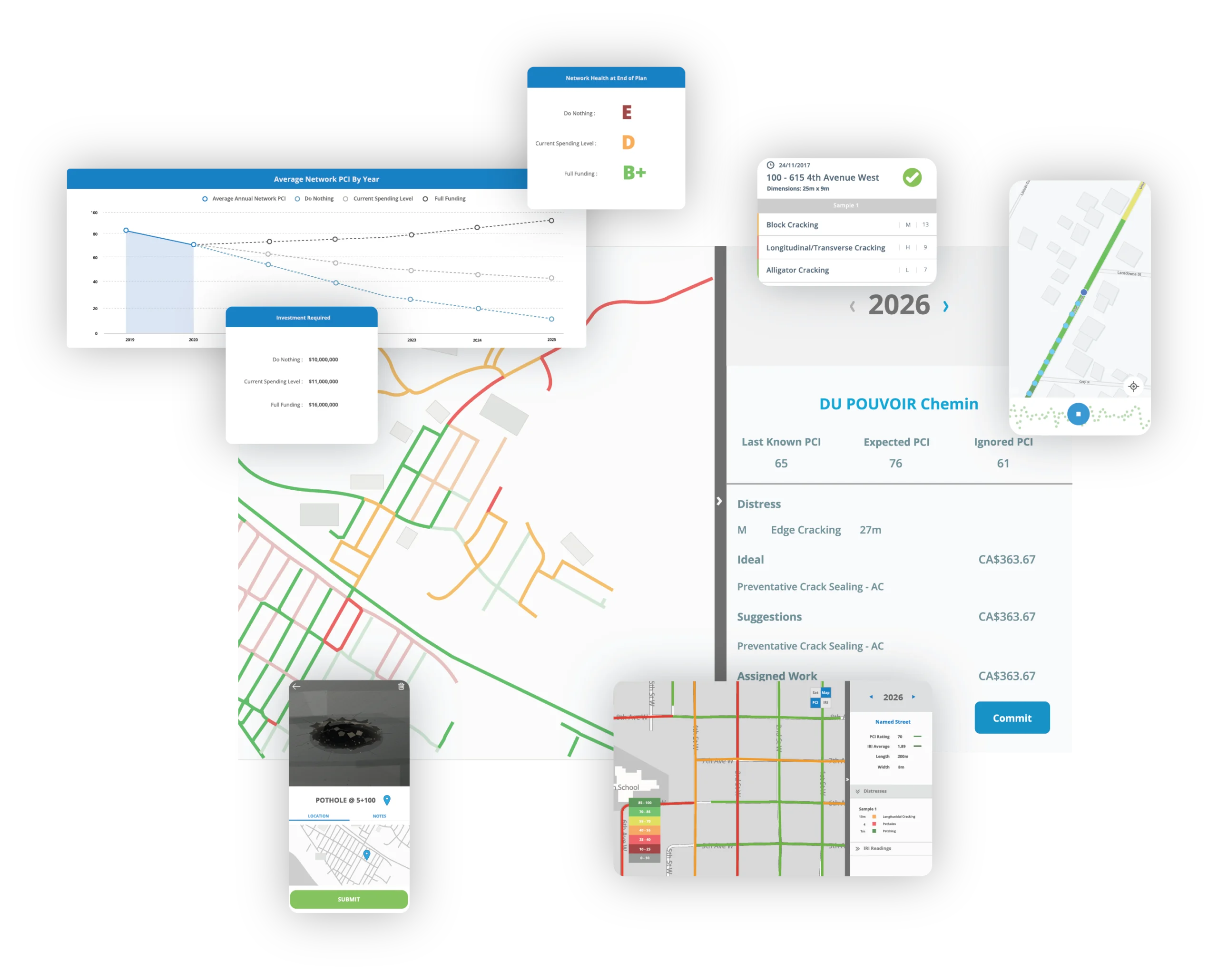
TotalPave PCI
Collect pavement condition data using a guided visual inspection workflow. TotalPave PCI helps your team document surface distresses, assign condition scores, and review results in the web portal alongside maps, imagery, and planning analytics.
Collect road roughness data using a smartphone mounted to the windshield of your vehicle. TotalPave IRI enables you to measure ride quality across your road network, review segment-level results in the web portal, and use roughness data to support maintenance and paving decisions.
Automate your pavement condition assessments using roadway imagery. SurfaceView PCI detects distresses, generate PCI results, and brings visual condition data into the same web portal used for mapping, planning, and reporting.
Turn IRI and PCI data into clear maintenance and paving recommendations. WorkPlan Analytics helps municipalities and road authorities compare road segments, evaluate budget scenarios, and build defensible road plans based on condition data, treatment needs, and available funding.
Set up the network once, refresh condition data as needed, review emerging needs, and update the program as funding and priorities change.
Step 1
Set Up
Start with existing GIS road centerlines or automatically generate interval-based road segments for your network.
Step 2
Collect
Use TotalPave mobile tools to collect IRI and PCI data with vehicles and phones you already have.
Step 3
Analyze
Review condition maps, segment scores, inspection records, and planning analytics in the web portal.
Step 4
Plan
Build a clear maintenance and paving plan that supports budgets, priorities, and council-ready recommendations.
MEASURABLE VALUE
Road asset management software that delivers value
Lower-cost collection makes it practical to update condition data more often, identify timely preservation opportunities, and test multi-year funding strategies.
20x
Lower data collection cost than traditional survey vehicles
10:1
Savings from timely preservation and avoided rehabilitation
5-year
Maintenance and paving plans based on condition and budget
2 metrics
IRI and PCI combined in one planning workflow
CORE CAPABILITIES
Tools for maintaining the program year after year
Keep the road inventory current, investigate changing conditions, compare candidate projects, and carry selected work into budgets and reports.
Apply treatment rules and local priorities to identify practical candidates for maintenance, rehabilitation, or resurfacing.
Budget Scenarios
Use TotalPave road asset management software to compare budget scenarios, prioritize candidate roads, and explain paving decisions with clear mapped data.
Reports and Exports
Export data for GIS, spreadsheets, council reports, asset management plans, and internal planning documents.
FAQ
Road Asset Management FAQs
Answers to the common setup, collection, export, and planning questions road asset managers usually ask before starting a road condition assessment.
Do we need special equipment?
No. TotalPave is designed around smartphone-based data collection using standard vehicles and practical field workflows.
Can our own staff collect the data?
Yes. Municipal staff can collect IRI and PCI data using the TotalPave mobile apps. TotalPave can also support setup, data collection, review, and analytics depending on the level of assistance required.
Do we need GIS files to get started?
GIS road centerlines are helpful, but they are not always required. TotalPave can work with existing GIS data or create interval-based road segments when needed.
How does TotalPave support paving prioritization?
TotalPave combines condition data, segment-level scores, and analytics tools to help identify which roads should be considered for maintenance, rehabilitation, paving, or future monitoring.
Can the results be exported?
Yes. Data can be exported for GIS, spreadsheets, reports, asset management plans, and other municipal planning workflows.
Can TotalPave help us create a road plan?
Yes. TotalPave analytics can be used to generate recommended paving and maintenance plans based on your road condition data and available budget.
What is road asset management software?
Road asset management software helps municipalities organize road condition data, map pavement needs, compare maintenance options, and plan paving work based on available budgets.
QUOTE
Ready to build a defensible road plan?
Tell us about your road network and current planning process. We will help you understand the simplest way to collect IRI and PCI data, review results, and turn them into budget-ready recommendations.