

Traditional pavement condition surveys can require trained staff to walk or slowly drive every road section while recording visible defects in the field. That approach can work well for smaller projects, but it becomes time-consuming when the network is large, traffic is heavy, or paved areas are difficult to access safely.
TotalPave SurfaceView shifts the pavement condition assessment out of the field and into a remote imagery-processing workflow. Instead of recording every distress at the roadside, clients collect pavement imagery and TotalPave completes the distress identification, quality assurance, PCI calculation, and delivery remotely. The platform is not tied to a particular camera or collection method. Suitable imagery may come from vehicle-mounted cameras, aerial drones, existing georeferenced image inventories, or another source that provides sufficient pavement visibility, resolution, location information, and coverage.
TotalPave processes the imagery, identifies pavement distresses, completes quality assurance, calculates section-level Pavement Condition Index results, and delivers the data through the TotalPave portal and standard exports. A previous TotalPave project provides a useful example of this imagery-first capability. The project covered more than 378,000 m² of paved assets across approximately 190 assessment sections. Aerial drone imagery was used because it was the most practical collection method for the size, geometry, and operational requirements of the facilities, but the downstream assessment workflow is independent of how the imagery is captured.
An imagery-first pavement assessment workflow
The first requirement for any imagery-based assessment is complete, consistent visual coverage of the pavement. The most appropriate collection method depends on the project. Imagery may be captured using a vehicle-mounted camera, an aerial drone, an existing georeferenced image inventory, or another suitable imaging system.
In the example project described below, high-resolution aerial images were collected using planned overlapping passes. Drone imagery allowed large and unusually shaped paved areas to be documented efficiently while normal operations continued. SurfaceView is not dependent on aerial collection. The same imagery processing, distress assessment, PCI calculation, GIS integration, and reporting workflow can be applied to suitable pavement imagery from other sources.
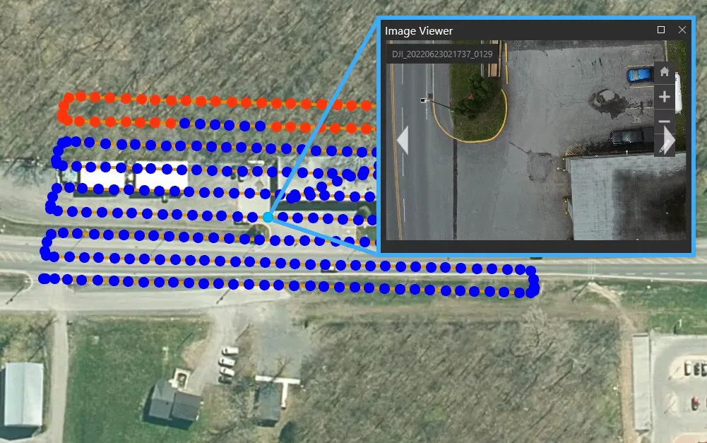
For a typical municipal road network, vehicle-mounted collection is often the simplest option. The client mounts a suitable camera to a vehicle and drives the required roads using collection instructions provided by TotalPave. A short test collection is reviewed before the full survey to confirm that the camera position, image quality, field of view, and collection settings are appropriate.
Where suitable imagery already exists, or where aerial collection is more practical, TotalPave can review the available material and confirm whether it meets the assessment requirements. This allows the imagery source to be selected based on the project rather than forcing every client to use the same collection system.
An imagery-first approach reduces the amount of detailed roadside survey work required. It also creates a permanent visual record that can be reviewed after collection, checked by additional staff, and referenced when questions arise about a particular pavement section.
Turning raw imagery into a usable pavement record
Raw images are only useful when they provide sufficient pavement detail and can be connected to the assets being managed. Regardless of whether the source is a vehicle-mounted camera, an aerial drone, or an existing imagery inventory, the images must provide suitable coverage, resolution, perspective, and location information.
In the example project, aerial images were processed into detailed georeferenced visual records that could be reviewed alongside the client's asset inventory. SurfaceView applies the same core process to other imagery sources. Images are organized by location and associated with the road network so that observed distresses and condition results can be assigned to the correct assessment section.
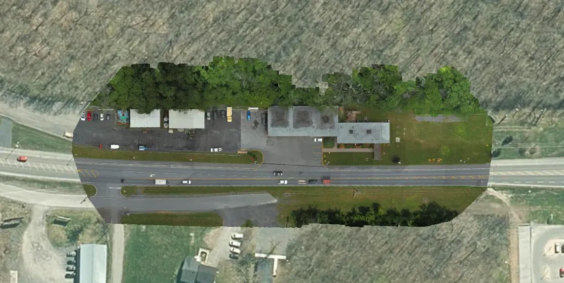
The reporting sections can follow the client's existing GIS centerlines and identifiers. They can also be created using intersection-to-intersection limits, fixed lengths, or another segmentation method suited to the project. This flexibility is important for consultants and municipalities because the final results need to fit the data structure already used for mapping, reporting, and capital planning. Learn more about how TotalPave uses consistent road line segments to organize and compare condition data.
Identifying pavement distress and calculating PCI
Once the imagery is prepared, the pavement surface is reviewed for visible distress. Depending on the pavement type, this can include cracking, patching, surface deterioration, rutting indicators, and other defects used in the ASTM D6433 Pavement Condition Index methodology, or other established surface condition assessment methodologies selected for the project.
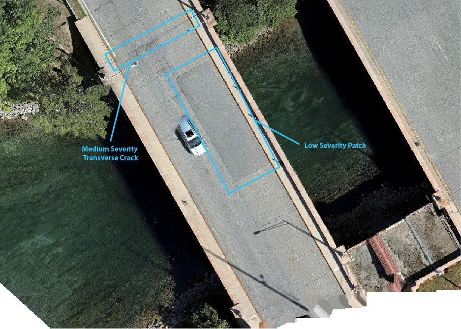
PCI converts the observed distress information into a score from 0 to 100 for each pavement section. A higher score represents pavement in better condition. Because the result is calculated at the section level, decision-makers can compare roads consistently, locate emerging problems, and separate candidates for preventive maintenance from sections approaching major rehabilitation.
Automated image analysis can assist with the assessment process, but useful pavement management data still requires quality control. TotalPave reviews the imagery and assessment results before delivery so that the final dataset is suitable for engineering review and planning.
Delivering results that fit existing GIS and reporting systems
The output of a SurfaceView project is not simply a folder of pavement photographs. Imagery from the selected source is converted into structured condition information that can be used across the organization.
Typical deliverables can include:
- Section-level PCI results
- Recorded pavement distress information
- Condition maps in the TotalPave web portal
- GIS-compatible spatial data
- Spreadsheet exports
- Supporting pavement imagery
- Summary reporting and condition statistics
- Maintenance and rehabilitation planning, when included in the project scope
These outputs can support existing asset management and mapping workflows. Esri's overview of its Roadway Management solution provides one example of how GIS can be used to organize roadway inventories, pavement assessments, and maintenance activities.
In the example project, the assessment covered asphalt, concrete, bridge surfaces, roads, parking areas, and other paved transportation assets. The overall network was found to be in Good condition, but the section-level results showed that condition varied significantly across the inventory.
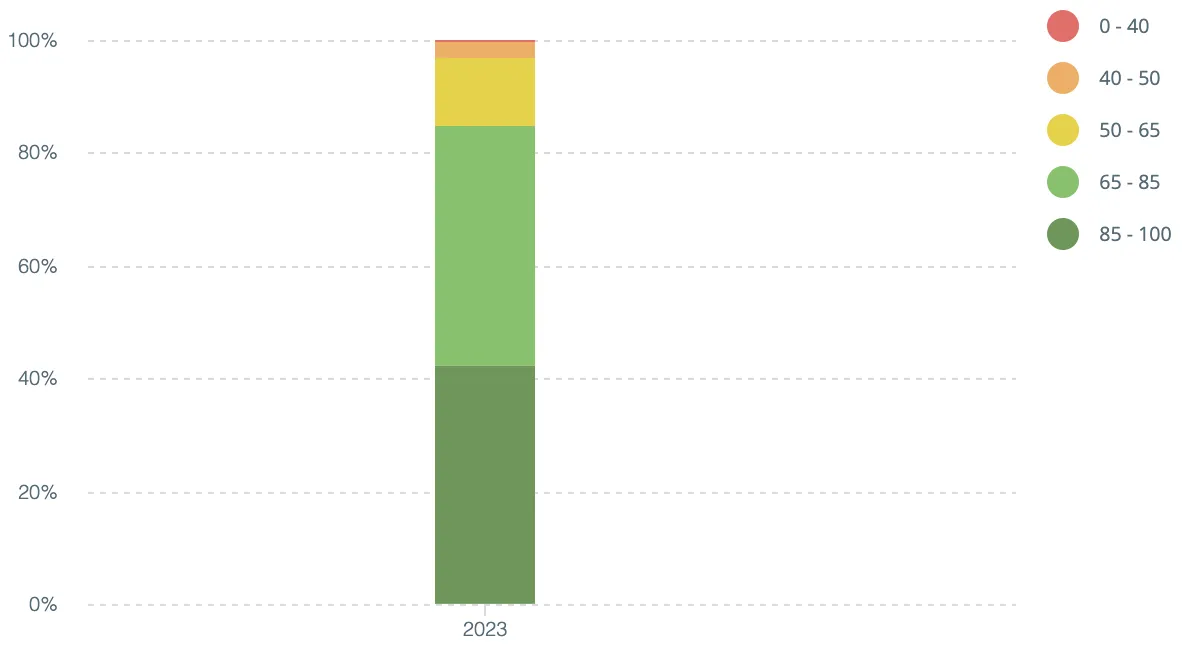
This distinction matters. A network can have a strong average condition while still containing individual sections that require immediate work. The project results identified several million dollars in major rehabilitation needs while also showing a substantial inventory of pavement that could be protected through timely preventive maintenance.
Using condition data to support five-year planning
A condition assessment establishes the current state of the network. Pavement management helps determine what to do next by connecting condition data with performance, maintenance needs, and investment decisions.
The project data was used to compare two five-year investment scenarios. Each scenario considered available budgets, pavement deterioration, treatment timing, and the sections eligible for preventive maintenance or major rehabilitation.
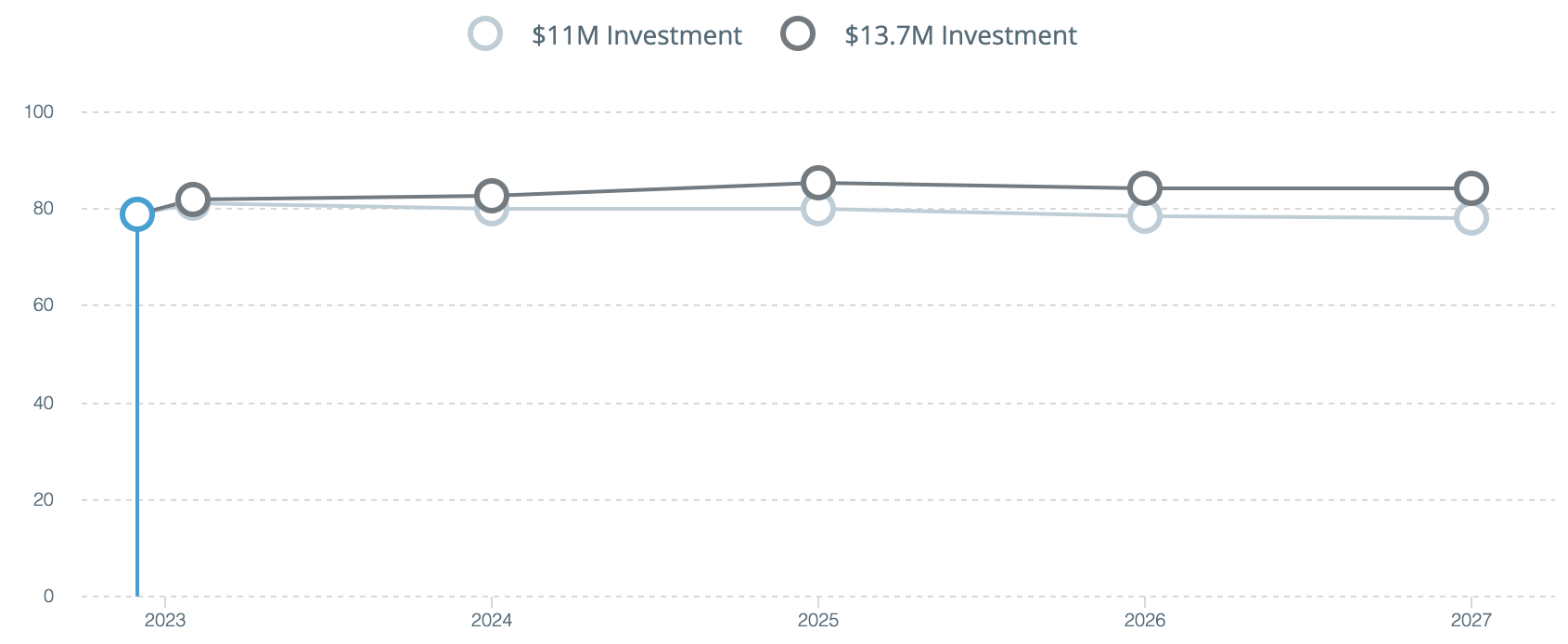
The analysis showed that both the amount of funding and the timing of the work influenced long-term results. The higher investment scenario allowed more critical rehabilitation needs to be addressed while improving the average condition of the network. The lower scenario preserved much of the existing condition but left less funding available for lower-priority assets.
This is where a repeatable condition dataset becomes particularly valuable. PCI results can be combined with treatment rules, unit costs, deterioration assumptions, and budget constraints to produce a practical work plan instead of a simple worst-first project list. WorkPlan Analytics uses these types of inputs to compare funding scenarios and develop prioritized paving and maintenance recommendations.
How SurfaceView works with different imagery sources
The example project used aerial drone imagery because it was well suited to the complex geometry and operational constraints of the paved areas. SurfaceView itself is imagery-source agnostic. The platform can use suitable pavement imagery from vehicle-mounted cameras, aerial drones, existing georeferenced image inventories, or other collection systems.
For conventional road networks, vehicle-mounted cameras are often the most straightforward and economical option because imagery can be collected while staff drive the network, sometimes alongside TotalPave IRI data. For large paved areas, restricted sites, unusual asset layouts, or projects with existing imagery, another collection method may be more practical.
A typical SurfaceView project follows these steps:
- Confirm the project limits, road length, GIS data, required deliverables, and available imagery.
- Review the existing imagery or select the most appropriate collection method for the project.
- Complete a sample review or short test collection to confirm pavement visibility, image quality, coverage, perspective, and location information.
- Collect or transfer the imagery to TotalPave.
- Process and organize the imagery by location and pavement section.
- Complete distress analysis, quality assurance, and section-level PCI calculations.
- Deliver the results through the TotalPave portal and standard GIS and spreadsheet exports.
The result is a scalable alternative to completing a detailed manual distress survey entirely in the field. Clients can use the imagery source that best fits the project rather than being restricted to a specific camera or collection platform. TotalPave manages the specialized imagery processing, pavement assessment, quality assurance, PCI calculation, and delivery.
Where SurfaceView fits
SurfaceView is particularly useful when a project requires defensible PCI results but the road length, traffic conditions, site geometry, schedule, or available field staff make a conventional walking survey difficult. Because the platform is not tied to one collection system, the imagery approach can be selected based on what is already available and what is most practical for the project.
Potential applications include municipal road networks, targeted rehabilitation studies, consultant-led pavement assessments, campuses, airports, industrial facilities, resource roads, parking areas, and other paved networks that need GIS-ready condition data.
To scope a SurfaceView project, TotalPave typically needs the approximate project limits or road length, the expected schedule, available GIS road data, required outputs, and information about any existing imagery. From there, the collection approach, imagery requirements, and final deliverables can be matched to the project.
Planning an upcoming pavement assessment? Contact TotalPave with the approximate road length, project limits, schedule, available imagery, and required deliverables. We can recommend the simplest collection and reporting approach for the project.

Use IRI to Reduce Haul Road Downtime, and Increase Safety
Haul road roughness monitoring using smartphone-based IRI data helps mines identify deterioration earlier, reduce the risk of unplanned downtime, protect expensive equipment,…
Read More
TotalPave IRI Supporting Rural Road Improvement in Sri Lanka
How TotalPave’s smartphone-based IRI data collection helped support large-scale rural road assessment for Sri Lanka’s Inclusive Connectivity and Development Project.
Read More
Is your organization ready for road condition data?
Avoid this simple (but common) mistake to ensure you get your road asset management planning started on a solid foundation
Read More